Skyline Trail Trailhead
This is a short, easy to follow trail with wonderful views of the Blue Ridge Mountains.
 1.1 MILE LOOP
DIFFICULTY: EASY–MODERATE
DRIVE TIME: 25 MINS
HIKE TIME: 45 MINS - 2 HOURS
DISTANCE: 1.1 MILE LOOP
DISTANCE: ADDITIONAL 0,2 MILE OUT-AND-BACK TO JEFFERSON'S POINT
VIEWS: BLUE RIDGE MOUNTAINS
* from Lexington Visitor Center, 106 E. Washington St.
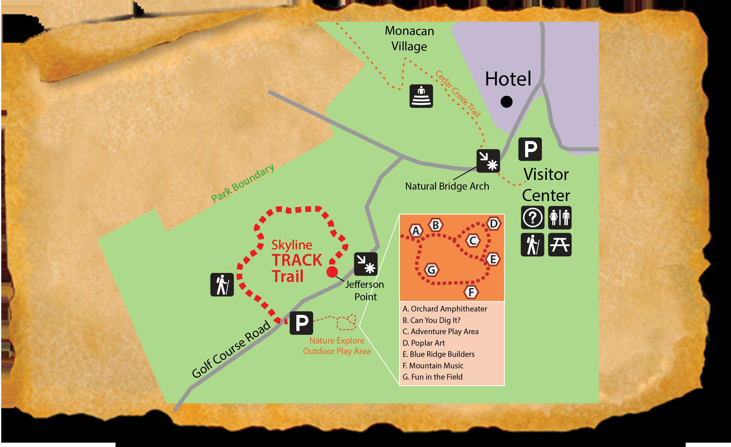
TRAILHEAD + PARKING
Large, level, gravel parking area, portable toilet, and numerous picnic tables. Visitors may use the self-service Pay Box in the parking area to pay the $5 Parking Fee.
DESCRIPTION
Located within Natural Bridge State Park, Skyline Trail, and the Kids in Park TRACT Trail, begin to the right of the kiosk. Follow the mowed path, cross the road (look for traffic) and begin a short moderate climb on a mowed path through a meadow of wildflowers. Near the top of this climb (0.25 miles) there is a wide opening with a bench with great view of Thunder Ridge Wilderness and the James River Face Wilderness.
The climb continues for a short distance with woods on the left then descends to a junction. The distance is 0.5 miles. The TRACT Trail continues straight out to Jefferson’s Point with benches, mountain views and an International Dark Sky strargazing site.
Make a left at the junction and begin to descend. Pass a bench on the right and turn left again to descend back to and across Golf Course Road. The distance is 0.6 miles. Contiue and the path passes through a narrow gap in the trees at 0.75 miles.
Continue into the Children’s Discovery Area (1.0 miles) and explore the area before proceeding to the parking area.
NATURAL BRIDGE STATE PARK ACTIVITIES
7 miles of trails
Children's Discovery Area
Kids in Park TRACK Trail: Skyline Trail
International Dark Sky Park
LOVEworks
KIDS IN PARKS, TRACK TRAILS
Skyline Trail shares a part of its trail with the Kids in Parks, TRACK trail, which follows the same path for the first 0.5 miles. The Kids in Parks, TRACK trails is a FREE, national program that connects families to the outdoors through hands-on exploration. Self-guided TRACK Trail activities and smartphone e-Adventures turn any outing into a fun-filled, discovery-packed adventure.
Brochures
Every TRACK Trail location is stocked with colorful, engaging brochures that offer fun, educational activities for all ages. The topics of the activities have been specially selected to help guide kids and families to the features of the trail. Some topics can be found at many different TRACK Trail locations, while others have been custom-designed to explore the unique features of the site. With dozens of activity brochures across hundreds of trails, every visit to a TRACK Trail becomes a unique adventure full of discoveries. Choose your favorite topic or try something new. Whether you want to search for wildlife, learn about plants, or burn off some energy, there's a TRACK Trail brochure for you.
E-Adeventure
Kids in Parks has converted some of our most popular TRACK Trail brochures into e-Adventures that kids can do on a smartphone or tablet. Kids can complete these e-Adventures in their backyard, schoolyard, local park, on an official TRACK Trail, or anywhere in between.
Information about the Kids in Parks Trail can be found here https://www.kidsinparks.com/na...

DETAILS: Click Website Link below for trail details, photos, and maps.
8am-dusk