Discover Buena Vista, Virginia
Bub Bub Subs is a laid-back local sandwich shop serving hearty subs, sandwiches, wraps, and classic comfort foods. Known for fresh ingredients and generous portions, the menu features everything from traditional deli subs and Philly cheesesteaks to wings, salads, and homestyle favorites. Whether you’re grabbing a quick lunch or fueling up after a day exploring the Shenandoah Valley, Bub Bub Subs offers simple, satisfying meals in a friendly small-town setting.
Hours:
Wednesday: 6 AM–9 PM
Thursday: 6 AM–9 PM
Friday: 6 AM–11 PM
Saturday: 6 AM–11 PM
Sunday: 11 AM–9 PM
Monday: 6 AM–9 PM
Tuesday: 6 AM–9 PM
This welcoming community hub brings together talented makers, artisans, and small businesses under one roof. Shop handcrafted goods, vintage finds, unique gifts, and locally inspired treasures—perfect for every style and season. Stop in, explore, and support the vibrant small-business spirit that makes Buena Vista shine!
MARKETPLACE
Open Wednesday-Saturday 10am-5pm; Closed Sunday-Tuesday
TAPROOM (opening April 2026)
Thursday 5pm-9pm; Friday 11am-9pm, Saturday 11am-9pm
Straws is Buena Vista’s hometown soda shop, serving up creative drinks, sweet treats, and a lively place to gather. Known for its custom sodas, loaded teas, and unique snack options, it’s a fun stop for all ages looking for a refreshing pick-me-up. With a casual, upbeat atmosphere and occasional live events, Straws is a favorite hangout in the heart of downtown.
Hours
Mon: 12:00 pm – 08:00 pm
Tue: 12:00 pm – 08:00 pm
Wed: 12:00 pm – 08:00 pm
Thu: 12:00 pm – 08:00 pm
Fri: 12:00 pm – 08:00 pm
Sat: 10:00 am – 08:00 pm
Sun: Closed
The shop offers custom cut vinyl monograms, logos, and lettering for items such as shirts, banners, home and wedding signs, and storefronts. It also includes a gift shop with a variety of items.
Little Beasties Art Studio is a creative space designed especially for children to explore art through hands-on projects, storytelling, and imaginative play. Located in downtown Buena Vista, the studio offers drop-in art experiences, classes, and special programs that encourage kids and families to experiment with a variety of materials and creative activities. With a focus on curiosity, creativity, and confidence, Little Beasties provides a welcoming place for young artists to learn, create, and have fun.
Hours
Sunday: Closed
Monday: Closed
Tuesday: 10 AM–3 PM
Wednesday: 10 AM–3 PM
Thursday: 10 AM–6 PM
Friday: Closed
Saturday: 10 AM–1 PM
Distance: 4.0 miles (one way)
Drive Time: 20 mins*
Difficulty: Moderate
Coordinates: 37.72248476238358, -79.34931458895488
Hike Time: 2.5 hours
Elevation Change: 880 feet
Views: Forest
* from Lexington Visitor Center, 106 E. Washington St.
DIRECTIONS
From the Lexington Visitors Center, turn left onto East Washington Street and proceed 0.25 miles to the stoplight on US 60 (East Nelson Street). Turn left and travel 6.0 miles to Beech Street. Turn right at the light. There is a Hardee’s on the right. Proceed 1.3 miles and turn left onto 13th Street. Continue another 0.7 miles and turn right onto Pine Street. Proceed 0.2 miles. Pine Street turns left into the woods. Park before the police firing range.
TRAIL DESCRIPTION
The trail description begins at a metal gate in Buena Vista. There is a small sign for the Reservoir Hollow Trail with the distance to Route 60 listed as 4.0 miles. Initially, the trail is wide and easy to follow. 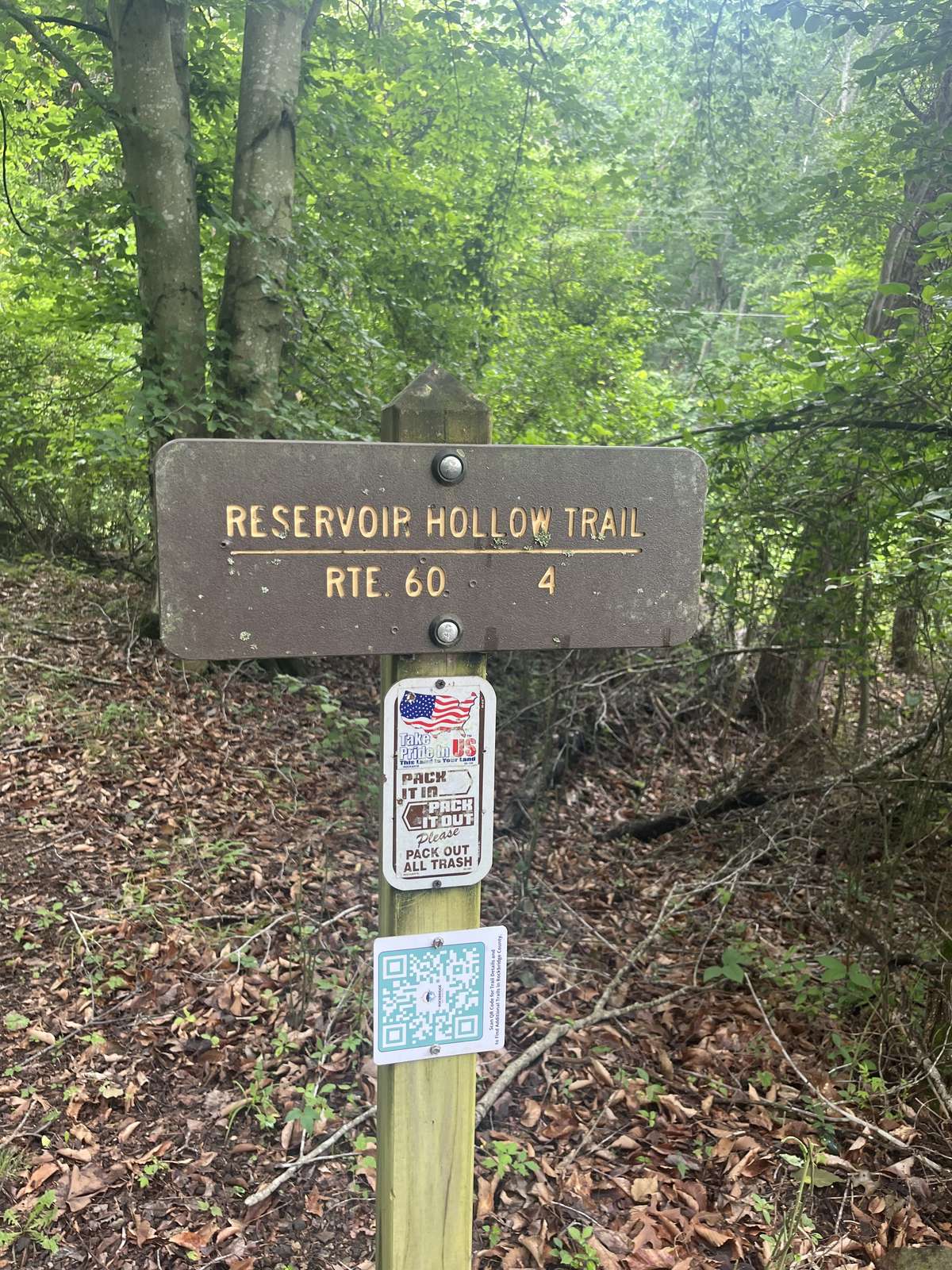 Noel Run is crossed within five minutes of the trailhead. If the water is high, it may be necessary to take off boots to cross. This is the first of six creek crossings as the trail climbs up through Reservoir Hollow.
On the right and left of the trail are large areas of scree slopes. Just past the screeslope, it is necessary to cross Noel Run again. Next, there is a junction of several trails. At the intersection, one trail exits to the left and follows the small stream up a narrow-walled canyon. A second bears to the right and follows the stream to old concrete ponds that served as water storage for Buena Vista. Take the trail that continues straight. Now, Reservoir Hollow Trail begins to climb.
After a brief climb, the trail bends left. After crossing the creek a third time, there is a wonderful bowl on the right filled with tall poplars and oaks. After the fourth crossing, the creek will be on the right. The grade is a gentle uphill. The trail is lined with boulders.
After the sixth crossing, the climb becomes moderate. A three-forked Chestnut oak marks a left bend, and the trail climbs a finger ridge away from Reservoir Hollow. The landscape is drier with Mountain laurel in the understory and pines and Chestnut oak in the overstory. Elephant Mountain is on the left.
A right switchback leads to the nose of the finger ridge. This is followed by a bend to the left and another right switchback. The climb is more taxing. At the left bend marked by a big, old pine, the grade changes from moderate to easy. Cross a small spring exiting the ground from under a boulder and pass through two boulder fields before reaching the saddle between Reservoir Hollow and Indian Gap Run.
Turn right to continue on the Reservoir Hollow Trail. The trail climbs briefly along an old road before entering the Indian Gap Run drainage. A right bend marks the top of the ridge, where the grade levels out and the forest opens into a park-like setting filled with tall poplars and oaks.
About 0.3 miles from the top, the Reservoir Hollow Trail intersects with the Indian Rocks Trail. There is no sign marking the junction. To stay on the Reservoir Hollow Trail, take the left fork. If you choose to go right, the trail continues uphill for about 0.4 miles to a rock outcrop. Along this route, you'll come across a distinctive man-made rock tower. 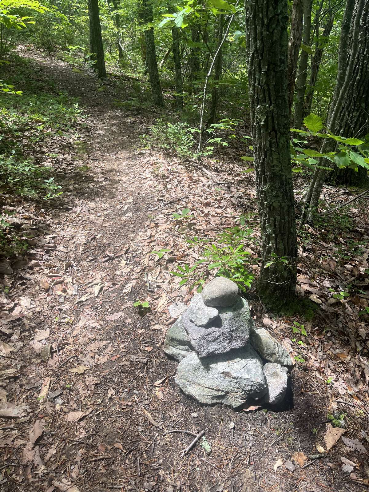 Just to the left of the tower, a narrow path branches off, follow it for a short distance to discover a stunning overlook of the surrounding landscape. It's a perfect spot to rest
 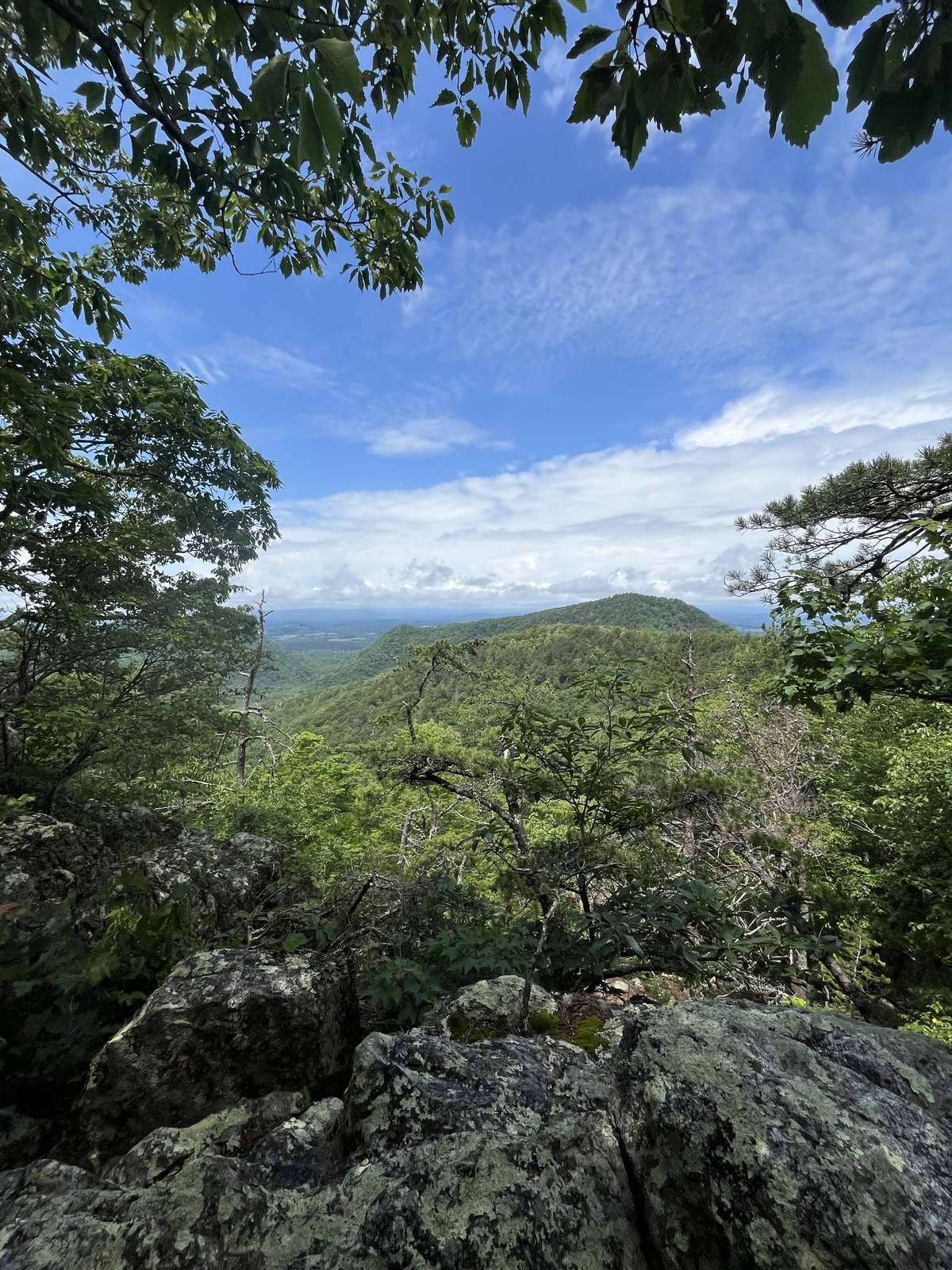 and take in the sweeping views.
Back at the junction, take the left fork to descend gradually to a smaller feeder stream. After crossing the stream once, it runs along the left side of the trail. Cross it a second time to reach Indian Gap Run and the junction with the long-forgotten Indian Gap Run Trail. This point is about 3.0 miles from the start.
The trail crosses Indian Gap Run and begins a gentle climb to a left bend, passes through a small boulder field, and enters a forest of yellow pine with Mountain laurel in the understory. A broad bend to the left brings you back into a canopy of tall cove hardwoods. In this hollow, a large boulder offers a quiet place to sit and enjoy the serenity of the forest.
After crossing the hollow and a small feeder creek, the trail begins contouring along the side of the mountain. It weaves through several small hollows and crosses over multiple finger ridges. Eventually, it passes under a power line before beginning an easy climb to a low saddle.
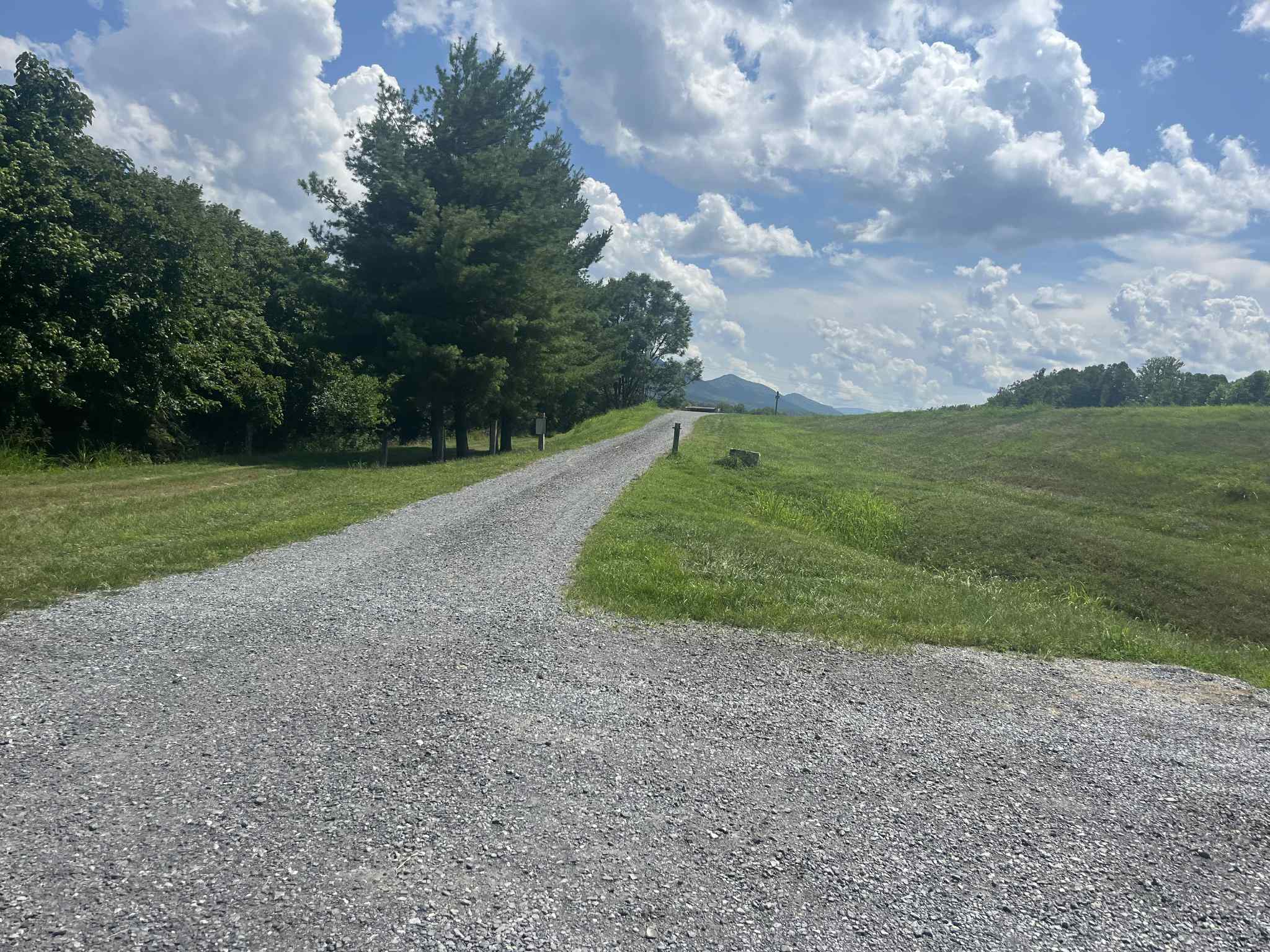
From here, the trail descends steadily, with a moderate grade. A right switchback is followed by a left switchback as the descent continues. The trail then crosses a small creek and makes its final descent to US 60. At the trail’s end, you'll find a sign for the Reservoir Hollow Trail; the distance back to 12th Street is 4.0 miles.
INSIDER'S TIPS
If you're hungry after the hike and looking for a quick bite, Buena Vista has some great local spots to check out! The new Five and Dime Pizza is already becoming a town favorite for its creative pizzas and cozy atmosphere. 501 Roadhouse LLC offers classic American meals and a laid-back vibe, and if you're craving something sweet or just need a refreshing pick-me-up, Straws is a Buena Vista classic.
Leaf & Lore is a welcoming space for readers and plant enthusiasts to connect, relax, and explore. The shelves are filled with a blend of new and beloved books, featuring works from local authors as well as celebrated voices from major publishers. In the plant studio, you have the opportunity to pot your own plants and take a piece of the shop home with you.
2.0 MILES
DIFFICULTY: EASY
HIKE TIME: 1.0 HOUR
DISTANCE: 2 MILES
ELEVATION CHANGE: 20 FEET
VIEWS: VERY DEVELOPED, NICE VIEW OF THE MAURY RIVER
DRIVE TIME*: 20 MINS
* from Lexington Visitor Center, 106 E. Washington St.
TRAILHEAD + PARKING
From the Lexington Visitor Center turn left onto East Washington Street. Proceed 0.25 miles to a stoplight and turn left onto East Main Street. Continue 6.1 miles and turn right at the stoplight just past the train bridge. This is US 501 South. Follow US 501 for 1.5 miles to a stoplight at the intersection of 10th Street. Turn right and continue for 0.1 mile to a parking area on the right.
Note: These directions will lead you to the parking area for both hikes.
Driving Distance/Time: 8 miles/20 minutes
DESCRIPTION
FLOOD WALL HIKE NORTH
At the parking area walk slightly downhill toward the sign that says “DOWNTOWN”. Turn left on the gravel path. The Floodwall Trail follows a narrow road. After passing the treatment plant, there is a left turn. The trail climbs up to the top of the flood wall.

On the floodwall, there is a right turn. The trail crosses a flood gate and continues straight toward downtown Buena Vista. The Maury River is on the right and industrial buildings are on the left. At 1.0 mile, a narrow road exits to the right. This leads to 21st Street and downtown Buena Vista. There is parking at the end of 21st Street. The Maury River walk continues straight another 0.2 miles to a barrier at the end of the flood wall.
FLOOD WALL HIKE SOUTH
From the parking area, cross the street and climb to the top of the flood wall. There is a bench on the flood wall. Once on top, the Maury River is to the left and a small rapid is visible from the walkway. The path follows the road along the top of the flood wall. About 0.2 miles there is a road that descends to the right. This road parallels the flood wall and can be used for a loop. Just past this side road, the path makes a long-left bend. There is another path that exits to the right and leads to a flood gate. There is a small bench at this junction. The flood wall continues beside the Maury River. Large American sycamores line the creek, and there are fields are on the left.
7.0 MILES
DIFFICULTY: MODERATE (DUE TO DISTANCE)
HIKE TIME: 3.5 HOURS
DISTANCE: 7 MILES (ONE WAY)
ELEVATION CHANGE: 125 FEET
VIEWS: FOREST, RIVER, GEOLOGICAL FORMATIONS, LOCK AND DAM RUINS, AND FARMS
DRIVE TIME*: 5-15 MINS
* from Lexington Visitor Center, 106 E. Washington St.
TRAILHEAD + PARKING
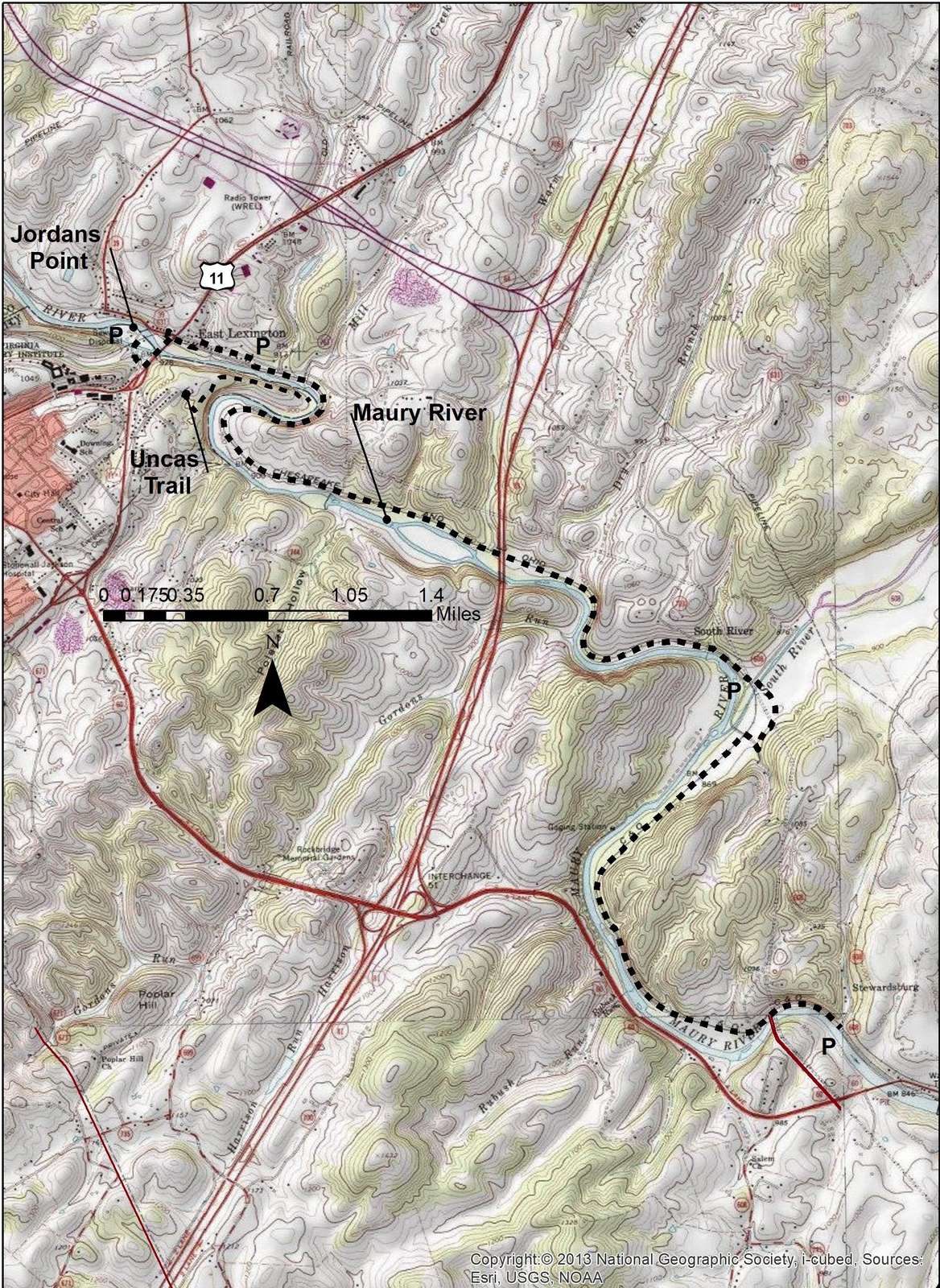
Jordans Point Parking: From the Lexington Visitor Center, drive west on Washington Street to a right onto Main Street (US-11 Business). Proceed 0.8 miles on North Main Street and bear to the left BEFORE crossing Veterans Memorial Bridge. Proceed. 0.1 mile and bear to the left onto Moses Mill Rd. Park at the pavilion on the right.
Note: There will be oncoming traffic when bearing left. There is a rest room at the pavilion.
Coordinates: 37.79205996401522, -79.4292204564924
Driving Distance/Time: 1.1 miles/5 minutes
Old Buena Vista Road Parking: From the Lexington Visitor Center, drive west on Washington Street to a right onto Main Street (US-11 Business). Continue driving north on US-11 and cross Veterans Memorial Bridge. Turn right onto VA-631 / Old Buena Vista Road. In one-half mile, just before the intersection with Lincoln Road, is a parking area on the right.
Note: This is the most used parking area for the Chessie Nature Trail.
Coordinates: 37.79165300188173, -79.42256857815002
Driving Distance/Time: 1.7 miles/6 minutes
Stuartsburg Road Parking: From the Lexington Visitor Center, drive west on Washington Street to a right onto Main Street (US-11 Business). Continue driving north on US-11 and cross Veterans Memorial Bridge. Turn right onto VA-631 / Old Buena Vista Road. Proceed 2.2 miles to Stuartsburg Road (CR 703) and turn right. Continue 1.3 miles. T
Note: This parking area is located at the South River.
Coordinates: 37.77091953000978, -79.38164659429611
Driving Distance/Time: 4.8 miles/12 minutes
Buena Vista Parking: From the Lexington Visitors Center, turn left onto East Washington Street and proceed 0.25 miles to the stop light on US 60 (East Nelson Street). Turn left and travel 5.3 miles. Just after crossing the Maury River, turn left on Stuartsburg Road (CR 703). Travel 0.1 miles to a parking area on left.
Coordinates: 37.745997463522734, -79.3704469701969
Driving Distance/Time: 5.5 miles/10 minutes
DESCRIPTION
This description begins at Jordans Point parking lot. Begin by walking toward US 11. At the sidewalk turn left and cross the Maury River on the East Lexington Bridge. At the stop light turn left on Furrs Mill Road. Walk about 100 feet and turn left onto a gravel path. The path drops down to the river and goes under the East Lexington Bridge. Continue an easy walk along the river to a parking lot. The distance to this parking lot is 0.7 miles. There is a port-a-john at this parking area.
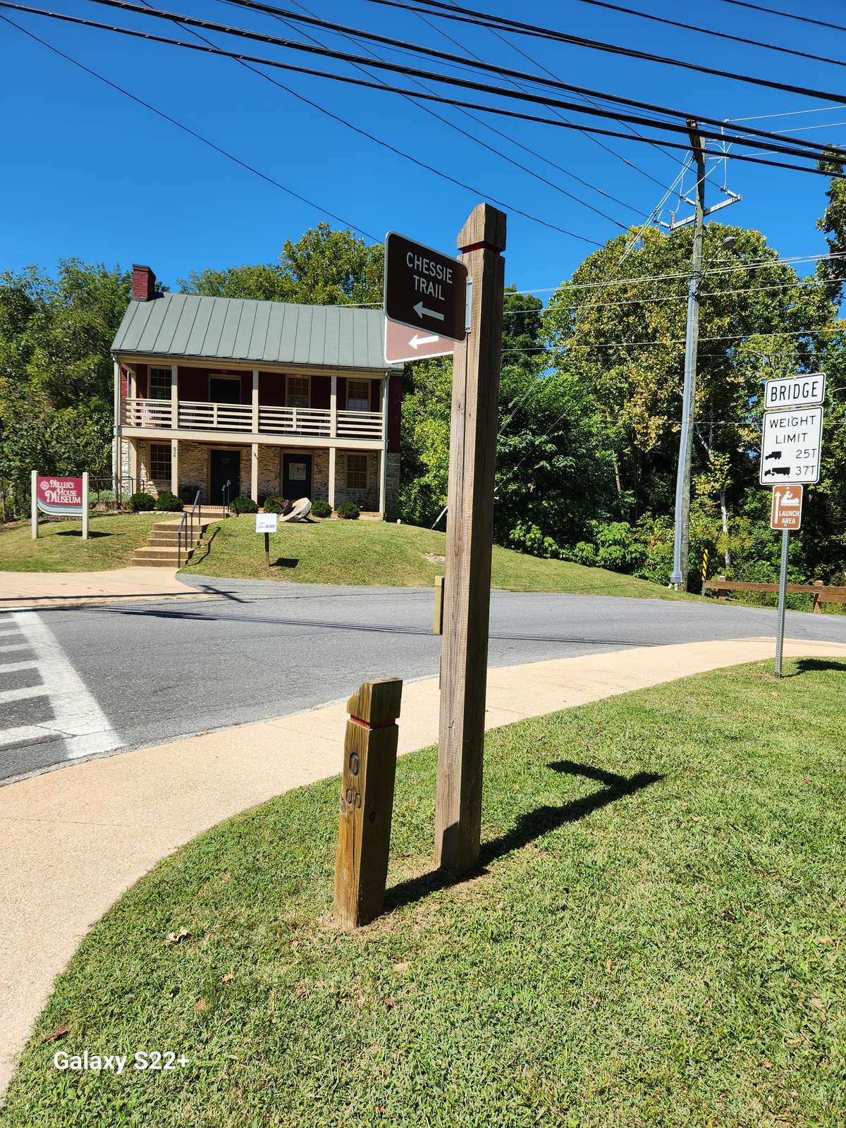
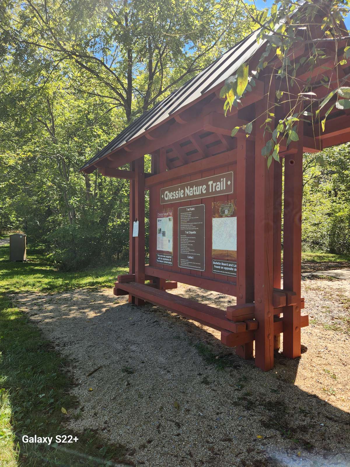
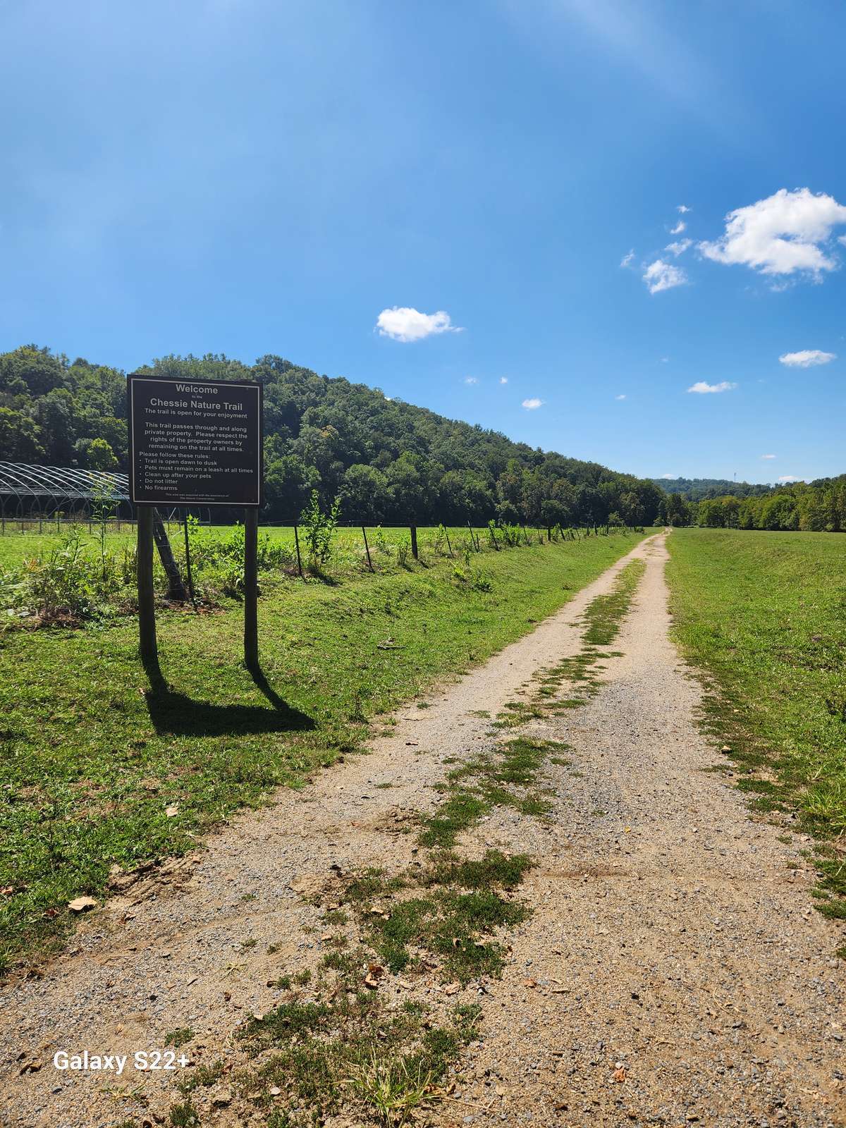
Just past the parking lot, the Chessie Nature Trail becomes a gravel path. It is straight and easy to follow. At 0.8 miles it crosses over a small creek. Just past the bridge is a trail crossing. A left leads to another parking area. A right leads to an overlook at the Maury River. The trail crosses over Mill Creek and begins a wide right turn. There is a kiosk with the dos and don’ts of trail etiquette. There are maps available as well and Mile Marker 1. This is the distance from Jordans Point. It is 0.3 miles from the parking area on Old Buena Vista Road.
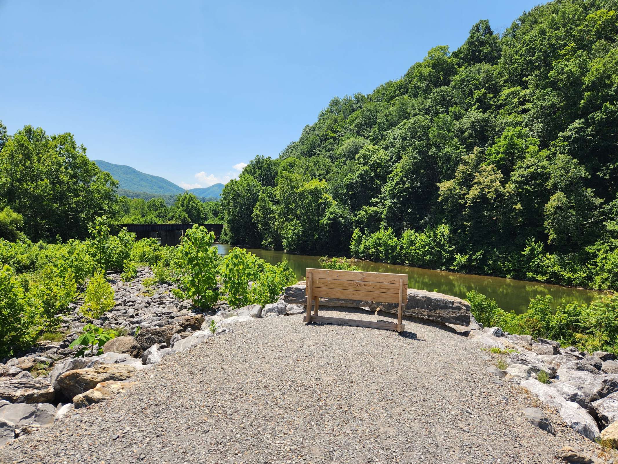
The trail begins a long right bend followed by a long-left bend. The left side of the trail is bordered by a towering cliff. At the transition from the right bend to the left bend, there is a small wooden bench to sit and rest weary legs. The distance is 1.5 miles. At approximately 2.0 miles is the old Reid’s Lock and the dam originally associated with the lock. Just past the lock is a small trail that leads down to the river. There is a flat rocky area to sit and enjoy the river.
Approximately 0.2 miles beyond the lock is a small bench on the left. At 2.5 miles there is a stand of bamboo on the right. The trail enters a long straight stretch before crossing over Warm Run and passes under the I-81 Bridge.
Near the interstate bridge, the trail passes out of the woods and into a pasture. Mile Marker 3 is on the left. Past the mile marker the trail re-enters the woods and begins a long right bend. It crosses Dry Creek via a large culvert. This is followed by a long-left bend. On the right is another set of towering cliffs. Near Mile Marker 3.5 there is a concrete post. On the post is BF 16. This is an old railroad marker providing the distance to Balcony Falls. There is also a tall cliff on the left. Across the Maury River a small set of shelf waterfalls tumble their way down to the river. This is Gordons Run.
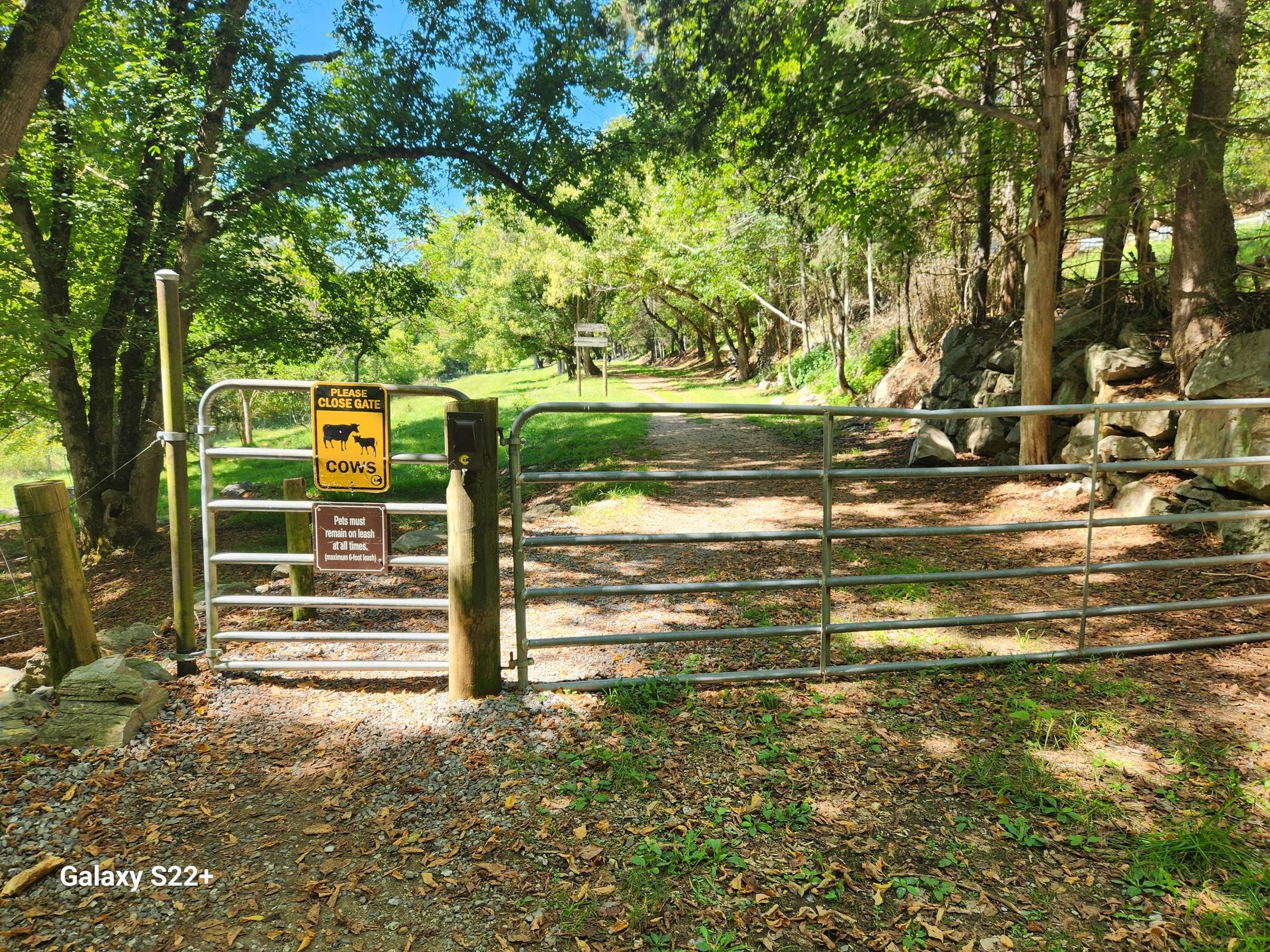
Near the end of this bend, the cliff gives way to a rolling hill. Tall Red, White and Scarlet oak dominate the canopy. The trail passes through a gate and enters a pasture. This area is surrounded by private property. Please stay on the trail. The trail now has a more farm use look. There can be cows on the path and lots of cow dung. It is important to watch your step. At the next fence, there is a spring on the right. The passes through another gate and comes to Mile Marker 4. The South River Lock is on the right.
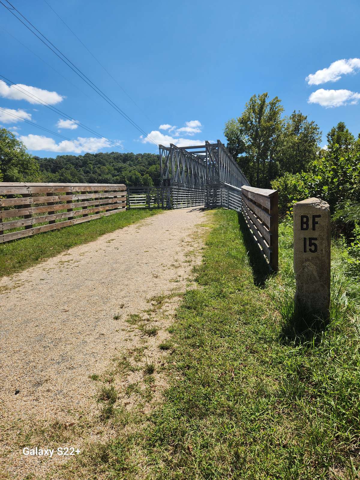
Just past the lock, The Chessie Nature Trail reaches the South River. There is a parking area, trash cans, and a sign for the Chessie Nature Trail. A new bridge has been built to replace the old train trestle that was washed away by the periodic flooding on South River. There is a concrete post with BF 15 just before the bridge. After the bridge, there is a long right bend. At the end of this bend is Old Sheppard Road. It is a dead end.
After passing through the gate, the trail enters a large pasture. On the right across the river is a large, old brick home. There is another railroad marker on the left. It has a “W” on it. After crossing a small creek, the trail re-enters the woods near Mile Marker 5. Not far beyond this post there is a cable car on the right that is used to cross the river. Additionally, there is a railroad maker in this stretch of woods with BF 14 on it. As the trail bends to the left, there is a tall cliff on the right.
Here it passes through another gate. Near the end of this bend, the locks of the Ben Salem Wayside can be seen across the river. The trail passes through another gate and enters another large pasture. This is near Mile Marker 6. This pasture usually has livestock and cow manure is a potential hazard. In places the trail can be muddy when the weather is wet. The trail continues its long bend to the left. It crosses a short bridge and just beyond the bridge there is a small spring on the right.
The trail passes another set of locks before passing through the last gate. On the other side of the fence, the river is very close to the trail. There is a cliff face on the left. After the pasture, the wooded over story is a welcome relief. The Nature Trail reaches Stuartsburg Road. Cross the gate on the right. Turn right and walk between the guardrail and the river. There is a path along the Maury River. This path is narrow at first but begins to widen as it approaches the parking lot. The parking lot is also a river access point that is operated jointly by VMI and the Virginia Department of Wildlife. The distance from the Stuartsburg Road of the Chessie Trail to this parking area is 0.3 miles.
ACCESSIBILITY
This 7-mile trail offers a variety of surface experiences throughout its length. The primary surfaces include:
- Packed Small Pea Gravel: Provides a firm and stable surface. (looser in some areas than others)

- Wooden Bridges: Allow for crossing water features or challenging terrain. The lips of these bridges are all on average, flush with the ground or rise no more than an inch, ensuring accessible passage for independent wheelchair users or for families with strollers.


- Packed Dirt: A natural surface type, potentially navigable with appropriate mobility devices.

- Packed Slightly Larger Gravel: I found that this is the least likely type of gravel to be used, but it's important to note that it does appear in some small portions of the 7-mile trail.

Trail Width:
The Chessie Trail maintains an average width of 8 feet, which is sufficient for passage by a wheelchair (power or manual) or strollers. This width is particularly beneficial for events such as the Chessie Trail Marathon and accommodates adaptive cycling equipment like hand bikes.
Slope and Grade:
The trail follows the former C&O railway line, designed with a gentle grade to accommodate trains. Consequently, the Chessie Trail is predominantly flat, with an estimated average running slope (grade) of 5% or less. This gentle grade makes it suitable for a wide range of users, including those utilizing mobility devices.
Amenities:
An accessible parking spot is available at the Lexington parking area, which is located just past the visible blue circular "PURE” sign. It is important not to confuse this parking area with one located approximately 3 minutes prior, coming from US11, as the entrance to that area has a steep grade and lacks accessible parking. An accessible Porta-John is also located near the accessible parking area.
- Note: While the accessible parking spot is designed for usability, during summer months and times of increased foliage growth, the surrounding vegetation may slightly reduce the available space.
DETAILS: Click Website Link below for trail details, photos, and maps.
1.00 MILE (LOOP)
DIFFICULTY: EASY
HIKE TIME: 45 MINUTES
DISTANCE: 1 MILE (LOOP)
ELEVATION CHANGE: 50 FEET
DRIVE TIME*: 20 MINUTES
*from Lexington Visitor Center, 106 E. Washington St.
DRIVING DIRECTIONS
From the Lexington Visitor Center, drive east on Washington Street to a left at the stoplight onto East Nelson Street / E. Midland Trail (US-60). Continue six miles into the City of Buena Vista. At the Hardee’s, turn right onto Beech Ave. (US-501). Continue through town and turn right onto 10 th Street, pass over train tracks, turn right into Glen Maury Park and check in at the park office.
Coordinates: 37.73442367147583, -79.36546783411794
Driving Distance/Time: 8 miles/20 minutes
DESCRIPTION
Glen Maury Park is Buena Vista’s 315-acre playground, providing wooded trails, an Olympic-sized pool, two campgrounds, as well as several pavilions where residents and tourists alike make the natural choice for enjoying life. Glen Maury Park hosts a variety of events each year – music from old time to classical, beach music to bluegrass, and gospel to rock n’roll. Around town you’ll find eateries and service businesses ready to provide what you need… all close at hand.
Activities include:
Hiking/Biking Trails/River Walk
Fishing
Paddling/Tubing
Bird Watching
Disc Golf
Gems of Rockbridge Geocache
Rockbridge Rangers
Music Events
Amenities include:
Upper/Lower Campgrounds
Olympic Sized Pool
Bike/Kayak/Tube Rentals
Playgrounds
Tennis Court
Ball Fields
Picnic Pavilions
Paxton House
FISHING
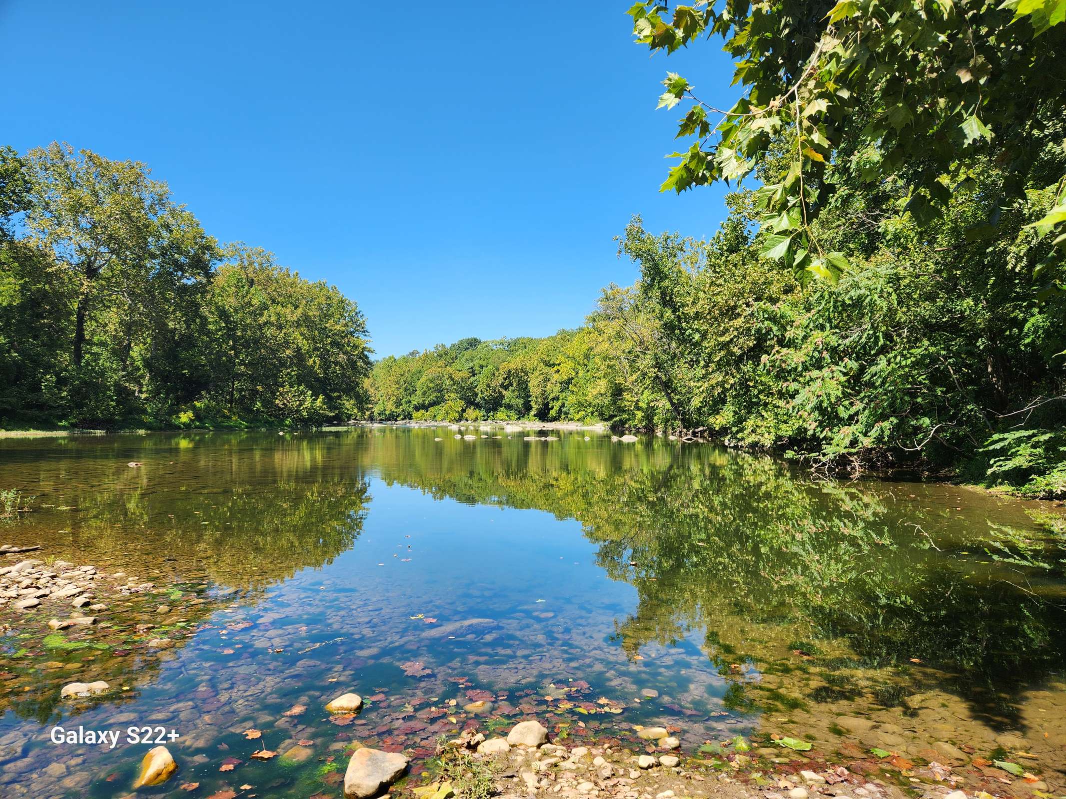
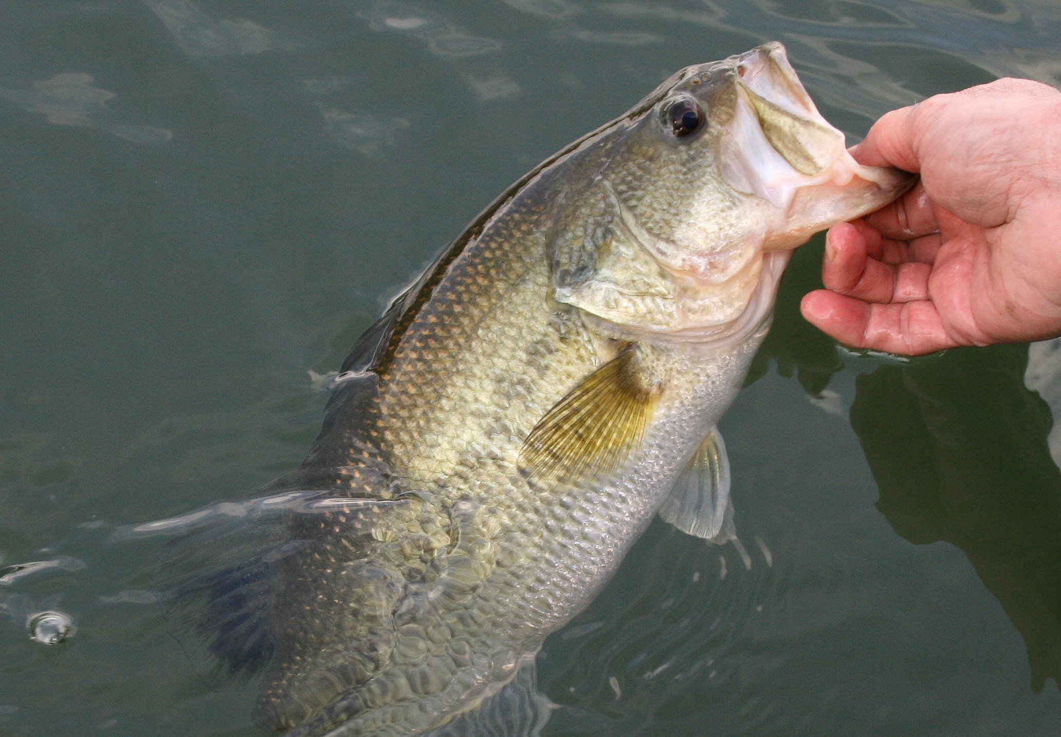
Once called “the North Fork of the James,” the most popular and prominent waterway in Rockbridge County is the Maury River, the carver of Goshen Pass, a water sports highway, and a thriving habitat. The ease of access to the Maury River makes it the most kid-friendly fishing opportunity in Rockbridge County.
The Maury River runs from its headwaters above Goshen Pass through Lexington and Buena Vista, and down to the confluence with the James River in Glasgow. Glen Maury Park offers shoreline and wading access to productive waters below the dam in Buena Vista, plus a boat ramp for canoes and small craft.
The warmer waters in this section offer more opportunities for largemouth bass as well as trophy size smallmouth bass, along with high abundance of panfish, carp, and fallfish. Musky are occasionally caught in this section as well, as holdovers from past stocking or migrants from the downstream James River population. The Maury River is stocked 9 times October - May.
- A state fishing license is required and can be secured at the Buena Vista Clerk of Court (2039 Sycamore Ave).
- Live bait is sold at Sheltman’s Gas & Grocery on 29th St.
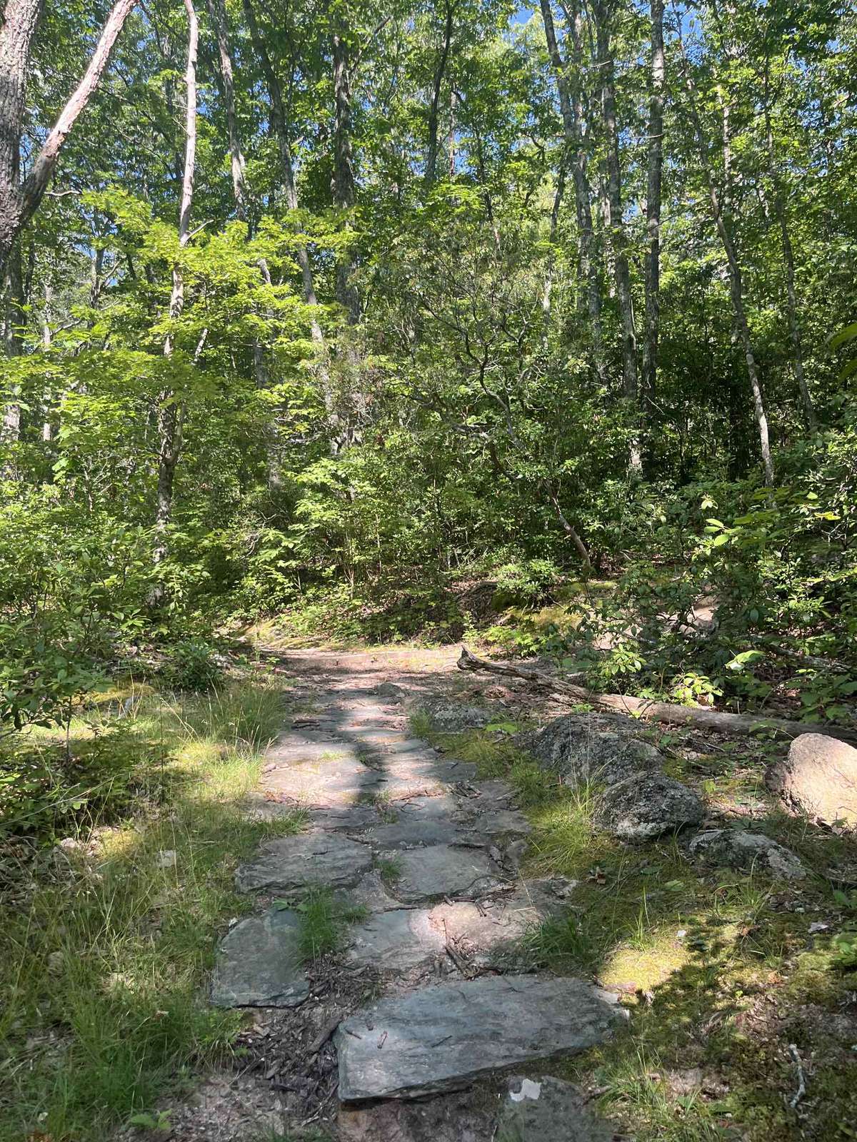
HIKING/BIKING TRAILS
A wooden kiosk at the park entrance features a map and the 13 trails. The trials can be accessed from many locations within the park and vary in distance and difficultly.
Fox Trot Trail (Kids in Park TRACK Trail)
This description is in a clockwise direction. From the Double Decker Pavilion area, the Fox Trot Trail enters the woods to the right of the kiosk with a map and nature brochures/storybooks. Almost immediately, the Gobbler Trail exits to the left. The Fox Trot Trail continues straight; the grade is easy. Within the first 500 feet is the first page of the storybook. Just after the storybook there is a switchback to the left followed by a switchback to the right. There is a wide bend to the right through a thicket of Autumn olive. Autumn olive was originally planted for game species to eat but it has become a terrible invasive plant.
At 0.25 miles the trail crosses a drainage and then a pipeline route. It reenters the woods where the second storybook page is located. The trees are mainly small cedar and cherry. These trees are usually the first trees when pasture is reverting to woodland. The trail is mostly flat and easy. The trail passes through a thicket of trees at 0.35 miles and just before crossing under a power line, there is another storybook page. It crosses under the powerline again at 0.5 miles. Just past the power line is another storybook page.
The trail intersects the Elevator Trail at 0.6 miles. It exits to the left and descends to the park road. The Fox Trot Trail goes through a series of easy ups and downs through a mature second growth forest. Tall straight oak and hickory dominate the forest canopy. At 0.7 miles there is another storybook page. A series of “S” bends help make a descent much easier. There is a wide right bend at 0.8 miles. This is followed by an easy climb and another storybook page. One of the metal baskets of the disc golf course is visible at 0.9 miles and at 0.95 mile is the last storybook page. Here the Fox Trot Trail bends left and then right as it passes between two large trees.
Finally, there is an easy climb into the grassy meadow. Continue uphill to reach the end of the loop.
Additional Trails
In addition to the Fox Trot Trail, there are several other trails in the park. It is possible to walk beside the Maury River or hike through less used areas of the park. For a pretty walk along the river, try the Floodline and Riverside Trails. The Hillside and Pic Nic Trails are quiet and immersive walks in the woods, with occasional views of the river. Deer sightings are likely! These trails can be used to make short loops and long day hikes. The possibilities are too numerous to mention. One thing is certain, the memories will last a lifetime.
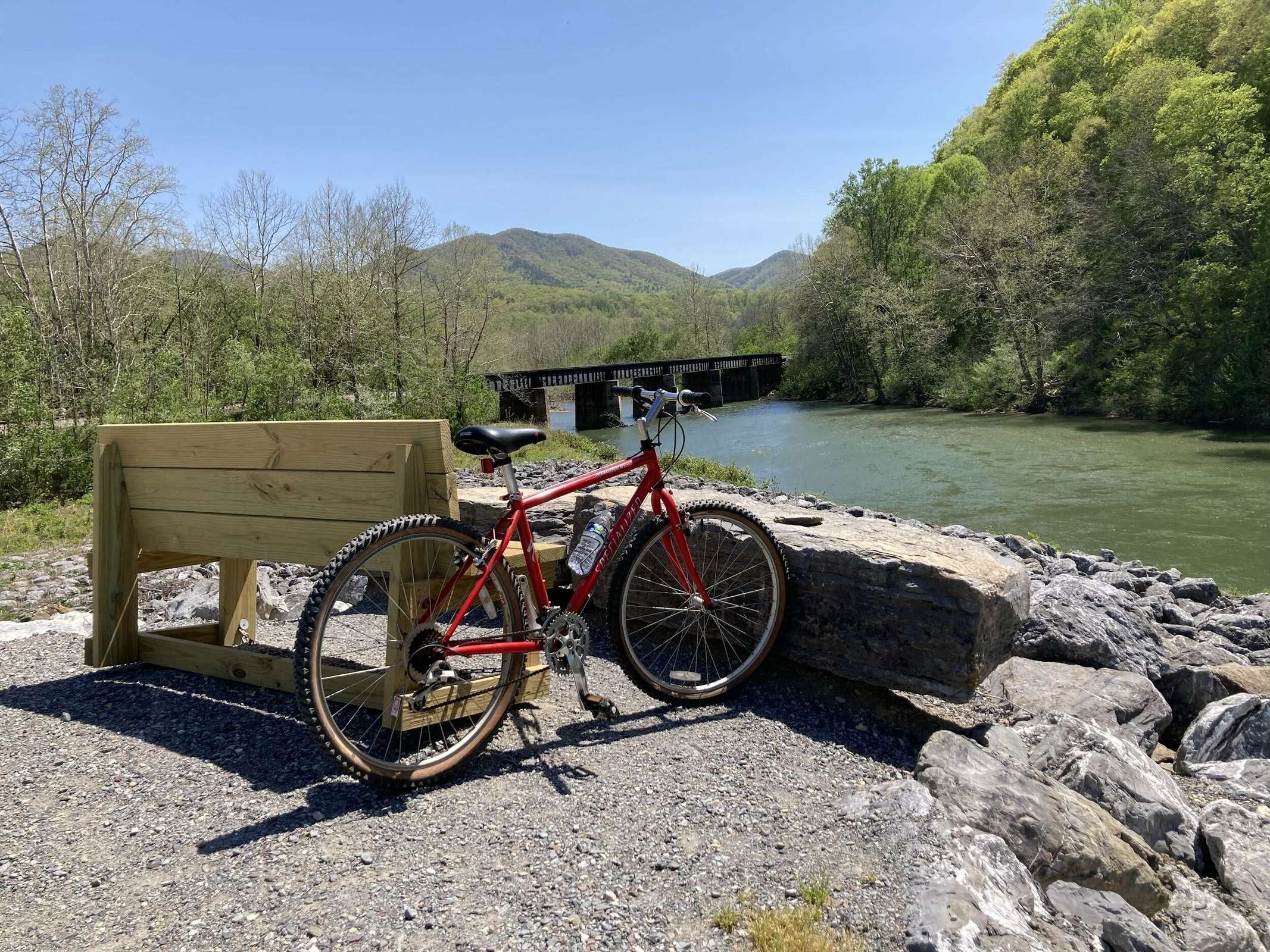
For more hiking and biking, cross the Maury River on the Veterans Memorial Bridge beside the park to access the three-mile River Walk, which unfurls along the top of the flood wall. From the northern end of the River Walk you can walk or bike just under a mile to connect to the multi-use Chessie Trail, which follows the river seven miles to Lexington.
Download Glen Maury Park Trail Map
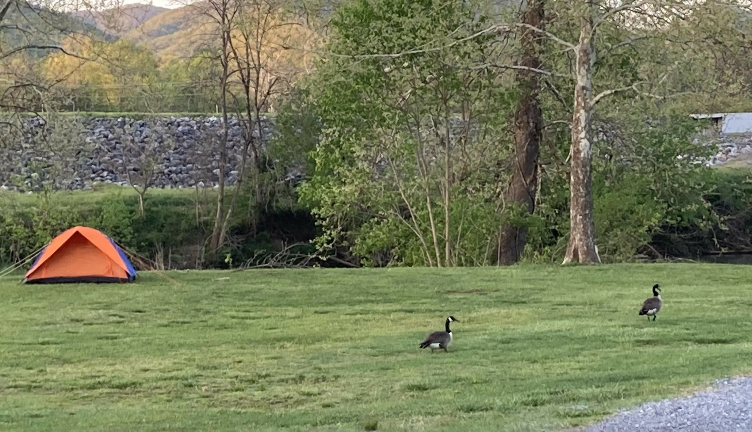
CAMPING
Glen Maury Park offers sites that range from primitive to full water, sewer, and electric hookups. Between the Lower Campground and the Upper Campgrounds, there are 100 tent sites and 42 full hook-up sites. All sites are first come, first serve—online reservations are currently unavailable.
Check camping RATES, or call 540-261-7321.
Lower Campground
RVers with big rigs, this is your happy place. The vast Lower Campground sprawls across a grassy field just beyond the park entrance. RVs and trailers line-up on a small rise overlooking the river. It’s a friendly scene, and during festival weekends folks gather for chats – often circling up their chairs for impromptu mountain-music jams. This is the campground for socializing and larger RVs.
- Tent campers pitch their tents below the rise, nestled along the Maury River.
- A covered pavilion, bathrooms, and showers are nearby.
- Two easy trails – the riverside Floodline Trail and the hillside Paxton Trail – connect with the Lower Campground.
Upper Campground
The Upper Campground is tucked in the woods atop a hill, with defined sites offering privacy and enjoying natural shade from the surrounding trees. This campground and its tight turns are best for small RVs.
- Nearby trails twist through the trees and drop to the river.
- The Olympic-sized pool, open in the summer, is also nearby.
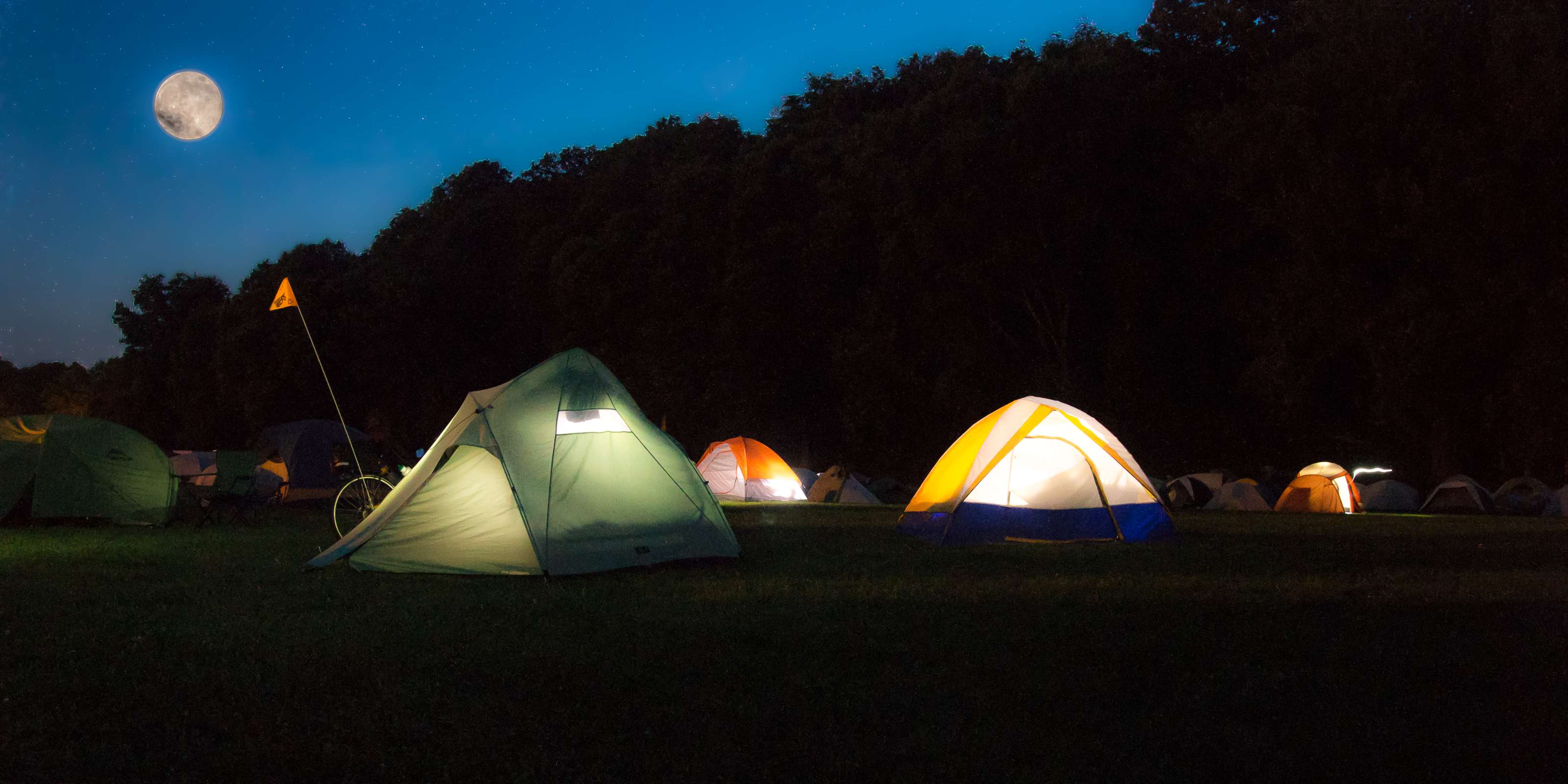
Appalachian Trail Thru-hikers
Buena Vista is an Appalachian Trail Community, meaning the city provides a friendly welcome and a slew of services to hikers walking the 2,190-mile trail. Thru-hikers can pitch their tents here for only $5 per night.
There's a tent area for AT campers by the river. If it’s raining, thru-hikers are welcome to sleep under the pavilion by the office. Park WiFi is strong here too. If it’s not busy, staff will let hikers use the showers for free, even if they’re not planning to camp.
- The Holy Cow ice cream shop beside the park office hands out a free ice cream cone to thru-hikers.
- There’s a convenience store three blocks away as well as a couple of BBQ joints.
POOL
Glen Maury Park Pool is an Olympic sized facility with covered picnic area, tables, and benches.
- Walk-in stairs with railings, handicap-accessible chair, progressive depth from 4ft to 12ft in the diving area, floatation devices are permitted.
- Wading pool with a water-spewing mushroom feature.
- Concessions and outside food/drink permitted (excluding alcoholic beverages)
- Non-smoking facility!
Hours:
Sunday: 1pm-6pm
Monday-Saturday: 11am- 6pm
Admission Prices:
Ages 13+: $4
Ages 4-12: $3
Ages 3 and Under: Free
Campers: $2
Non-swimmers: $2
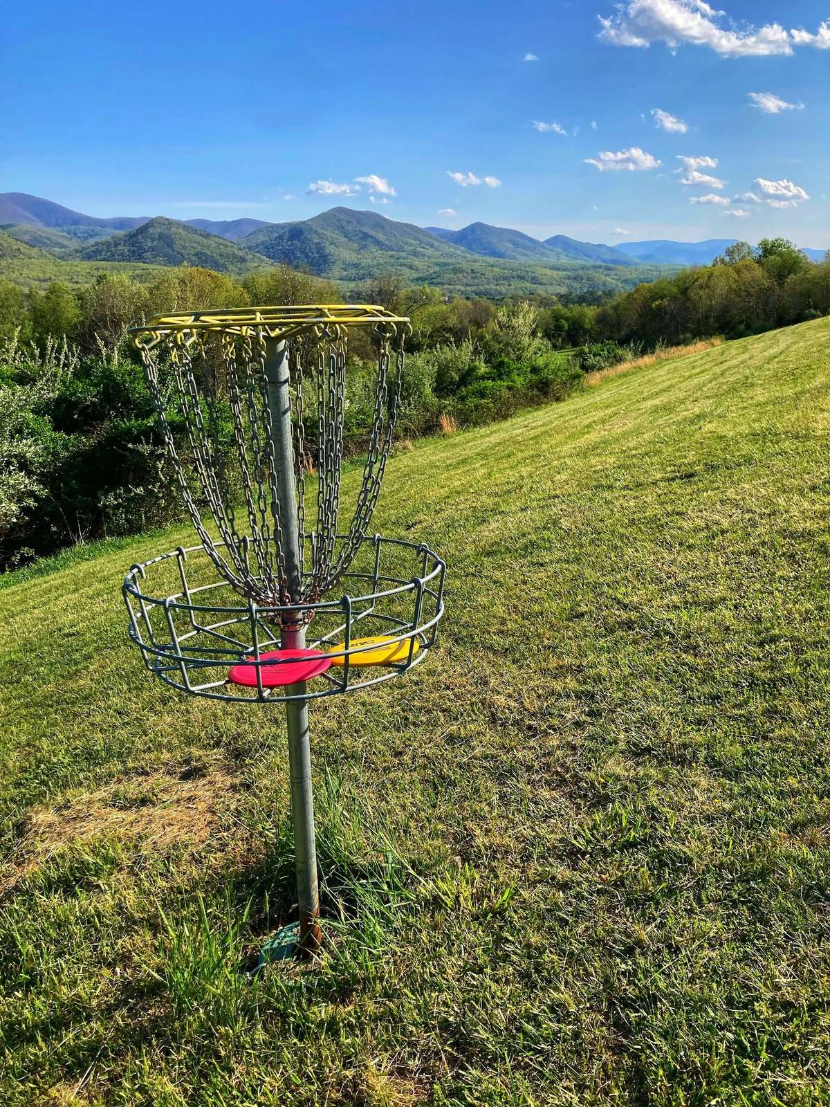
DISC GOLF
A nine-basket disc golf course loops around the Double Decker Pavilion near the upper fringes of the park. A multi-phase work-in-progress, the course is waiting for its tee-pads, but if you’re game for “wild” disc golf, it’s easy to follow the route. Installed by the Outing Club at Washington & Lee University, the course meanders along a grassy hillside before entering the woods at the top of the hill. Views of the Blue Ridge Mountains and Buena Vista are impressive.
BIRD WATCHING
Maury Park is a stop on the Rockbridge River and Ridge Loop on the Virginia Bird & Wildlife Trail, which includes several bird-watching destinations in and around Lexington and Buena Vista. The park is home to a thick grove of hardwoods close to the river while white pines appear at higher elevations. Green and great blue herons might be spotted along the river as well as Canada geese and belted kingfishers. Look for woodland birds like the pileated woodpecker on the upper hillsides.
ACCESSIBILITY
Trail Surfaces & Width
Primary trail surfaces include paved paths, packed gravel, loose gravel, and roadway sections. Surface type may vary depending on your location within the park.
Trail width generally ranges from 4 to 8 feet.
Amenities & Facilities
Restrooms:
- Wheelchair-accessible restrooms are available near the park entrance, with large stalls for ease of use.
- At the Double Decker Pavilion, both restrooms are accessible: The men’s restroom has a smooth transition from grass to concrete. The women’s restroom has a taller lip (approximately 3 inches), which may require assistance.
- Restrooms near the recreational stage are accessible via a ramp, though the incline is quite steep. Independent wheelchair users may need assistance navigating the slope.
Parking & Play Areas:
Accessible parking is available near the entrance and the playground.
The playground includes:
- A swing with a backrest to prevent forward falls,(ADA SWING)
- Musical instruments placed low to the ground for easy reach.
- Note: There is a significant lip at the playground entrance, which may pose a barrier for some users.
- The entrance to the main office, where visitors can rent or purchase camping gear, is accessible via a ramp.
Campground Accessibility:
- The lower campground is flat and great for setting up camp, the other campground sites are located on a steep incline and not recommend for mobility device users.
- Campsites are grass-covered and include electric outlets at each site.
Recreational Stage:
- The stage has a ramp for access, but the incline is steep.
- Restrooms near the stage are accessible via the same ramp.
Other Facilities:
- The tennis area gate entrance is narrow and does not open fully.
- Both pavilions near the park entrance are accessible and ideal for gatherings or casual use.
- The pool at Glenn Maury Park is equipped with a chair lift for water access.
River Access & Kayaking:
- Glenn Maury Park is located near a kayak launch site, with access to the river just a short distance from the main recreation area.
- Visitors can slide down the grassy bank at a commonly used spot for launching kayaks, this informal entry point is often preferred due to its smoother approach.
- A paved sidewalk runs alongside the river, offering a scenic route for birdwatching and enjoying views of the water.
- There is a wheelchair-accessible ramp into the river intended for kayak launching; however, it is not ideally maintained and may be difficult to use independently.
- Many visitors instead use the smooth, gently sloped riverbank located directly in front of the sidewalk as a more practical alternative for launching kayaks.
Art on Magnolia is a downtown Buena Vista gallery featuring oil and watercolor paintings from local and international artists, set between the Blue Ridge Mountains and the Maury River.
The Blue Ridge Abbey is a beautifully restored historic home turned bed and breakfast, blending timeless charm with modern comfort to offer guests a memorable stay in Buena Vista.
Distance: 0.2 miles (One way)
Difficulty: Easy
Elevation Gain: Minimal
Hike Time: 20 minutes
Parking: Indian Rocks pull off on the Blue Ridge Parkway
Coordinates: 37.67407242011223, -79.33428267261804
Driving Distance/Time: 15 miles/30 minutes
DIRECTIONS
Turn left on East Washington Street and travel 0.3 miles to East Nelson Street and US 60. Turn left on East Nelson Street and proceed 13.3 miles to the crest of the Blue Ridge Mountains. Turn left on the Blue Ridge Parkway Access Road and travel 0.1 miles to the Parkway and turn left. Proceed south on the Parkway 1.9 miles to a small parking on the left. There is a sign for Indian Gaps Rocks at the parking area.
DESCRIPTION
Initially, the trail is gravel, but the gravel soon gives way to a pine needle-covered trail. The trail makes a right bend and passes through a thicket of Mountain laurel and rhododendron. White pine and Pitch pine are in the canopy. The huge boulders of the Indian Gap are visible. The trail travels around the tall boulder field. There is also a tunnel formed by some of the rocks. Loop around the boulders and return via the same route. Be careful if climbing the boulders.
Offering specialty coffees that are locally brewed each day. Online sales available, venue space for parties, club meetings, weddings and birthdays available to reserve.
Hours of Operation:
Monday 7 am to Noon
Tuesday 7 am to Noon
Wednesday Closed
Thursday 7 am to Noon
Friday 7 am to Noon
Saturday 8 am to 2 pm
Sunday Closed
AMENITIES
Groups Welcome (10+ people)
Pets Welcome
Wheelchair Access
Meeting Facilities
Wedding Venue
UNDER TWO MILES
Distance: .4 miles out and back
Drive Time: 30 mins*
Difficulty: Leisurely stroll
Coordinates: 79°29'43.781"W 37°46'39.145"N
Hike Time: 30 minutes
Views: Wild & Waterfall
* from Lexington Visitor Center, 106 E. Washington St.
DIRECTIONS
From the Lexington Visitors Center, turn left onto East Washington Street and proceed 0.25 miles to the stoplight on US 60 (East Nelson Street). Turn left and travel 10.2 miles. Just past the entrance to the Blue Ridge Parkway, turn right on Panther Falls Road. Proceed 3.3 miles to a small parking area on the left.
TRAIL DESCRIPTION
At the parking area, a Forest Service information kiosk provides details about the trail and the surrounding landscape. The Panther Falls Trail begins to the left of the kiosk, descending at an easy grade for about 100 yards before reaching the Pedlar River. From here, the trail turns right, following the river downstream.
The stream bank, lined with Tulip poplar, musclewood, and sycamore, adds to the scenic beauty of the hike. Along the way, hikers will cross three small feeder creeks before reaching an area of large boulders, where Panther Falls is located on the left.
The short 0.4-mile hike to the falls offers visitors a choice of a low or high road upon arrival. However, the trail is muddy due to small stream crossings, so caution is advised. The undercut ledge ringing the pool and the strong currents can make climbing out of the water challenging. Slippery rocks further increase the risk of falls.
Importantly, swimmers should use extreme caution, tragic accidents have occurred from diving into the pool below the falls. Whether hiking or swimming, visitors should remain mindful of the terrain and water conditions to ensure a safe and enjoyable experience.
TIPS
- In the summer, the parking lot is packed until the early evening. If you want to skip the crowds, come early on weekdays or in the early evening. Avoid weekends if crowds are undesirable.
- Because the trail is muddy, flip-flops are not recommended.
- Alcoholic beverages are prohibited in and around the Panther Falls area.
INSIDER'S TIPS
- Sit down for BBQ at JJ's Meat Shack in Buena Vista.
- Bring out a hammock and a picnic and enjoy the sounds of the calming waterfall and children playing. Up and downstream from the falls are several pools that are relaxing as well.
- Nearby, just off the Blue Ridge Parkway, is the Cole Mountain Trail, sometimes called the Cold Mountain Trail. It is also worth a hike for the stunning views it affords from its mountain meadows.
- The new Five and Dime Pizza is already becoming a town favorite for its creative pies and cozy atmosphere. 501 Roadhouse LLC offers classic American meals and a laid-back vibe, and if you're craving something sweet or just need a refreshing pick-me-up, Straws is a Buena Vista classic.
Hibachi entrees, noodles, and sushi rolls in Buena Vista.
Ice cream and souvenir shop in Buena Vista.
Buy local produce and food every Thursday from 2-6 at The Square on the corner of 21st and Magnolia Avenue in Buena Vista, VA