Lake Robertson Trail Loop
The Lake Trail is an easy loop around Lake Robertson. It is a trail that any family can enjoy. This wooded path crosses the dam, passes through wooded forest, and offers numerous places to sit and enjoy the sounds of the outdoors. In the evening sometimes it is possible to see beavers swimming in the lake.
UNDER TWO MILES
Distance: 1.75 miles (Loop)
Drive Time: 27 mins*
Difficulty: Easy
Coordinates: 37.80276734531683, -79.6100690963469
Hike Time: 1.25 hours
Elevation Change: 50 feet
Views: Lake & Forest
* from Lexington Visitor Center, 106 E. Washington St.
DIRECTIONS
From the Visitor Center, turn left onto East Jefferson Street. Proceed 0.3 miles to a stoplight on Nelson Street. Continue another 0.3 miles and turn right onto the US 11 bypass. Travel 0.9 miles to a stoplight and continue straight. This is Link Road, which turns into Collierstown Road (CR 251). Once on Link Road/Collierstown Road, it is necessary to make a right turn to stay on Collierstown Road. At the old Effinger School, turn left to stay on Collierstown Road. Just past the Collierstown Presbyterian Church, turn left onto Turnpike Road (CR 770). Travel 1.4 miles to the entrance to Lake Robertson Recreation Area. Continue 0.5 miles to the boat ramp.
TRAILHEAD & PARKING
There are two main trailheads for the Lake Robertson Trail. The first is near the entrance to the A. Willis Robertson Recreation Area. This trailhead features an overall map of all the trails surrounding Lake Robertson. The green dashed lines on the map represent the Lake Trail itself.
After checking out the trailhead, follow the road straight, do not turn into the playground or camping roads, until you reach the lake parking lot. There, you'll find the second trailhead, which includes fishing regulations and a Rockbridge Outdoors QR code.
TRAIL DESCRIPTION
The trail crosses a narrow wooden bridge on the left side of the landing area. After crossing the bridge, the trail makes a wide left bend and passes through an area of small yellow pine and cedar. There are also many Wineberry and Black raspberry canes. On the right there are many short trails that lead down to the lake. The trail makes a left bend and right bend before crossing two small bridges. After crossing the second bridge, the Possum Pass Trail exits to the left.
About 100 yards past the Possum Pass junction, the trail follows a wide, grassy road. It is flat and easy to follow. Near the halfway point, there is a kiosk on the left. After the kiosk, the trail bends right and passes through a wet marshy area. This old marsh is a remnant of old beaver activity. The trail crosses a small creek before making a quick climb to an intersection with a road. Turn right. A left leads to the Turkey Roost Trail.
The trail exits the road to the left and crosses a small bridge. On the other side of the bridge, it becomes a path again, climbing away from the lake and into the woods. The grade is easy. The forest is mostly mixed hardwood trees. Some of the trees exhibit scars of beaver activity. The hardwoods give way to small pine and cedar and the trail begins a series of short ups and downs before dropping a short distance.
Quite suddenly, the trail breaks out of the trees and begins a short, steep climb along a chain link fence. At the top of this climb, there is a nice view of the lake. The Turkey Roost Trail exits to the left. Next, the trail drops steeply to the spillway. After crossing the spillway, it then crosses the earthen dam.
On the opposite side of the dam, the trail re-enters the woods. About 0.1 miles after entering the woods, the trail splits. A left leads to the playground and the picnic shelter. This portion of the trail is a slow, easy climb. At the top of the climb, turn right to reach the shelter.
A right leads down to the lake. Take the right turn. The trail stays close to the shore and crosses one bridge. Sometimes this part of the trail can be muddy. About 0.25 miles from the bridge, the trail comes to a large wooden deck overlooking the lake. Beyond the deck, the trail climbs rapidly toward the road. Just before intersecting the road, the trail turns right and drops back to the lake and the boat ramp.
There are several other trails at Lake Robertson that can be combined for loops of various lengths and difficulty. They include the 1.4-mile Grouse Haven Trail. The 0.25-mile Fox Path. The 0.5-mile Squirrel Run. The 1.1-mile Hawk Creek Trail. The 1.0-mile Deer Lick Trail. The 0.4-mile Possum Pass Trail and the 1.75-mile Turkey Roost Trail.
Note: Hiking on Game Management Land requires a permit. The permit can be obtained by going to the Department of Wildlife Resources website. Hiking without a permit can result in a ticket and a fine. No permit is needed to hike around the lake.
INSIDER'S TIP: Near the entrance to Lake Robertson, there’s a small information center that sells basic camping and fishing gear, along with free map pamphlets for the area. Keep in mind, they only accept cash or checks, and internet service is unreliable, so plan accordingly.
After your hike, extend your adventure by bringing a picnic, fishing pole, or swimsuit to enjoy the park’s amenities. If you’re up for it, consider an overnight stay at one of the camping sites or cabins.
This hike is also just a short drive from North Mountain, so double the fun with another trail nearby!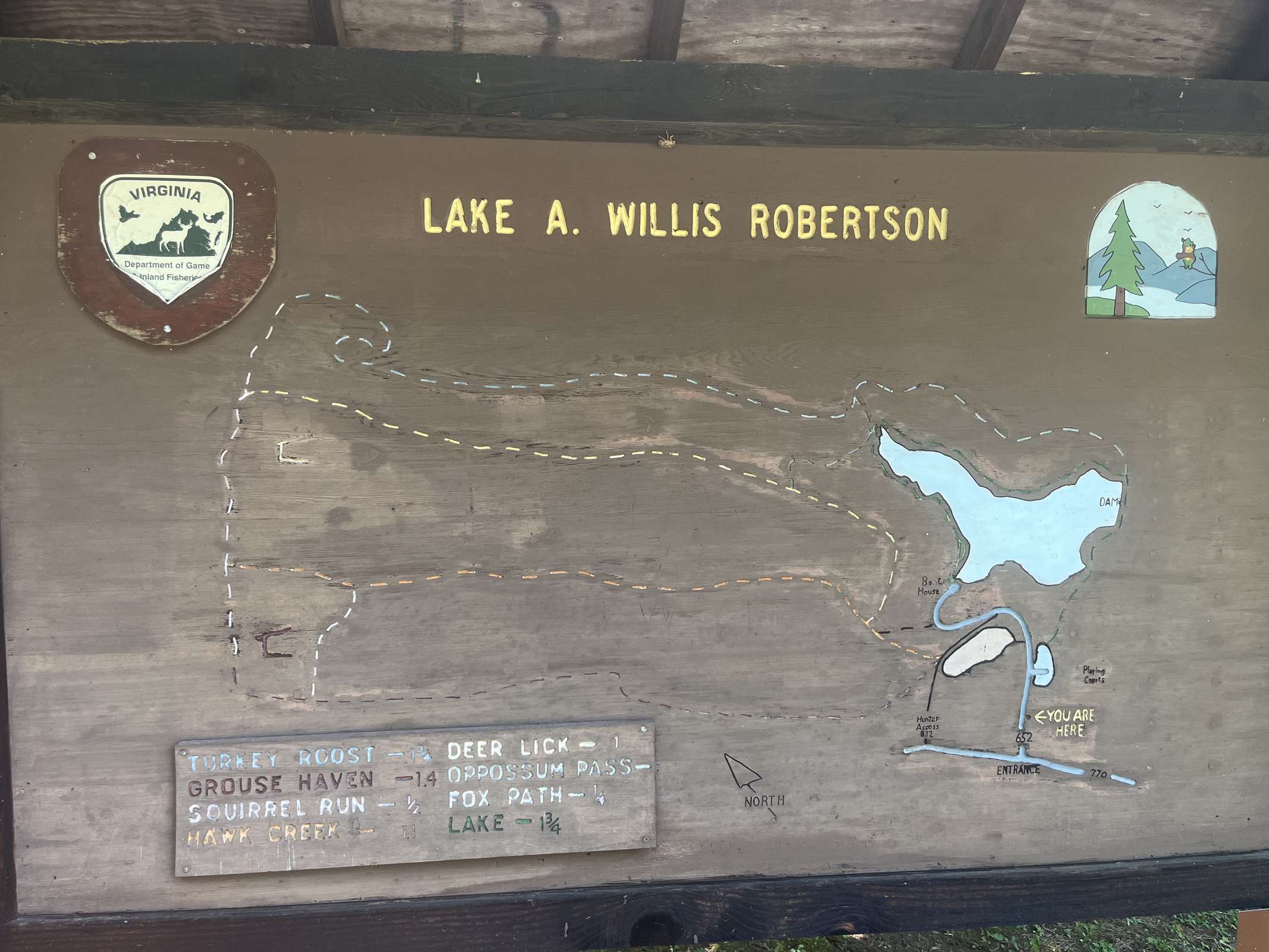
Fishing hours vary. The park closes at 9 PM.